How can the coming tsunami of connected vehicle data be harnessed and channeled to solve the mobility challenges facing cities, making their roads safer? Ford Mobility has addressed this question with an extensive two-year study in London, Western Europe’s largest city with nine million inhabitants. Using smart algorithms to correlate granular vehicle data from a connected fleet with readily available public datasets, Ford has demonstrated the capacity of data analytics to help implement London’s bold transportation agenda in five key areas: road safety hotspots, electric vehicle infrastructure, traffic retiming, mode-shift analytics and reassessing traffic metrics. The company will take the insights glimpsed in the study to other European cities, while eyeing a brave new world of data-driven solutions built on cloud-based platforms common to all smart city participants.
“We aimed to establish the power of vehicle data and provide actionable solutions to cities, rather than ju st a holistic idea that data is the future,” says Ford project lead Jonathan Scott. “We decided to address policy intentions when London’s Mayor, Sadiq Khan, issued his Transport Strategy in 2017.”
Data collection
Alongside ambitious environmental and congestion targets, this strategy included a Vision Zero commitment to eliminate all road fatalities by 2041.
“That prompted us to ask: How do you get there?” Scott continues. “If you’re forever reacting to accidents you will never achieve Vision Zero, and the Safe Systems approach requires infrastructure that is tolerant of human imperfections. By combining historic accident data and real-time vehicle data to predict where accidents will happen, we can allow cities to progress from reactive to proactive management of road safety.”
Light commercial vehicle (LCV) use in London is expected to grow 22% by 2031. Data collected over 12 months from a 160-strong Ford Transit LCV fleet yielded 500 million datapoints covering a million miles of recorded driving.
“LCVs are a growing segment in London and an important part of Ford’s traditional business,” says Scott. “Using a plug-in device to collect a host of rich data, 160 vehicles gave us real insight into how those vehicles were used across London. We needed to work out the optimum data rate. Monitoring rapid steering manoeuvres requires second-by-second data, but to monitor whether headlights are on, it can be once every five seconds.”
Scott’s team collected additional data from a private-use Ford Fiesta fleet and worked with Ford’s US-based Global Data Insight and Analytics (GDIA) team to evolve vehicle records into actionable insights.
“As our dataset grew, we learned more about the information that exists in a city,” says Scott. “That was when the magic started to happen.”


Watching the magic unfold
To predict accidents before they occur, Ford took historic accident data and identified risky driver behavior at those locations using metrics such as speed, hazard-light usage and braking patterns.
“A smart algorithm then looked across the whole of London to see where those behaviors are repeated without necessarily leading to accidents,” says Scott. “It’s based around the near-miss protocol in modern health and safety. We can predict where the next incident might occur so that cities can investigate and identify future infrastructure changes to reduce those events.”
This could often entail relatively minor and inexpensive improvements such as cutting back vegetation concealing signage or installing traffic-light violation cameras. Instead of waiting for accidents to occur, authorities can proactively mitigate dangers.
Each year, the average Londoner spends three days stuck in traffic. Congestion costs the city an estimated £9.5bn. Transport for London’s (TfL) retiming policy aims to ease network pressure by encouraging LCV fleets to shift operations outside of rush hour.
“Rather than just asking them, we wanted to inform fleets of the benefits, using vehicle data,” says Scott. “We meshed together real-world fleet operations data with speed and traffic flow information at different times of day, so that fleets could weigh up the benefits of retiming versus the logistical impact of deliveries arriving too early, for instance.”
The study suggested that by setting out two hours earlier, a fleet could save 60 hours per week, lending TfL’s policy a compelling evidential basis.
“Using granular data, we could boil that down depot-by-depot or vehicle-by-vehicle,” Scott adds. “It might be worth retiming not the whole fleet, but just a few individual routes.”

Optimization
London’s Ultra-Low Emissions Zone came into force in 2019 as part of a radical program to improve the city’s air quality. Electric vehicles (EVs) have a crucial role to play but range anxiety remains a problem due to inadequate charging infrastructure. With London investing in additional charge points, Ford used real-world fleet movement and downtime data to show where these could be optimally placed.
“There are more than 500 charge points in London, but we found that most vehicles didn’t stop for long enough or close enough to use them,” says Scott. “Then it dawned on us that we could flip this round by positioning charge-points based on actual fleet operations.” Only 1% of tracked vehicles stopped within 100m of existing charge points, but Ford estimate as few as 20 new rapid charge points in strategic locations could significantly improve EV viability across the whole of Greater London. Ford believe automated charge-point positioning will interest not only London’s city planners but municipalities across the world regulating to reduce urban emissions.
Getting people onto public transport is central to London’s transport strategy and, as with fleet retiming, Ford vehicle data provided route-specific evidence of the potential benefits. Comparing journey times from Ford’s Fiesta fleet with multi-modal API data and transit timetables revealed that 20% of driven journeys would be quicker by public transport, cycling or on foot. A web application developed by Ford to enable journey-time comparison offers a potentially powerful tool for encouraging people to shift modes. Such information could also allow authorities to target public transport investment on routes where transit times compare less favorably with driving.
Surprises on the road
Vehicle data provides potential to develop a nuanced understanding of traffic flow across a city. As part of its project, Ford set out to interrogate the so-called ‘summer holiday effect’: the assumption that roads will be less congested during academic recess. By measuring actual vehicle speeds against speed limits on a road-by-road basis, they compared traffic flow across London in a normal week with a week in the holidays. While a lack of school-run traffic was shown to improve travel-times in most areas, congestion on certain roads, including the A13 and A406 North Circular, actually increased during the holidays.
“Granular data allows you to look at shorter lengths of road across time,” says Scott. “This offers the ability to focus increasingly scarce resources on the most challenging sections
of the road network.”

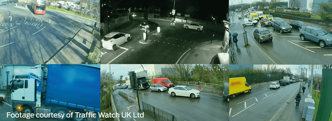
Having created a snapshot of how data from just 160 vehicles could serve to optimize a city’s transport system, Ford is ready to engage with authorities worldwide and has already extended its data analysis to Valencia in Spain and Cologne in Germany. Armed with predictive analysis, Ford is now working with civil engineers at Traffic Watch UK to analyze driver behavior at eight potential London hotspots and explore infrastructure adaptations that could mitigate risky driving patterns. Specific recommendations such as installing red-light cameras or double-height signage, resurfacing carriageways or increasing lane widths at junctions have been shared with relevant local authorities. “The next step is understanding how authorities can consume these insights,” says Scott. “We have to understand existing ecosystems in order to build a tool that’s tailored to real-world use of this data.”
The future
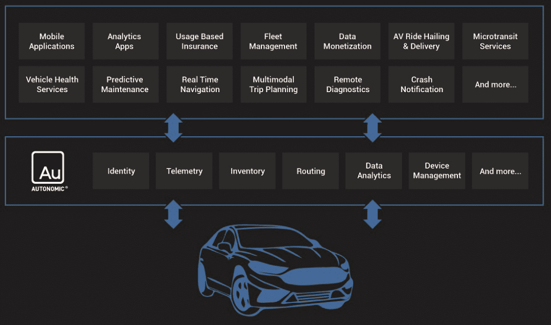
Looking ahead, Ford advocates pooling data from various components of connected cities – vehicles, public transport and infrastructure – into an open, cloud-based platform called the Transportation Mobility Cloud (TMC). Developed by Ford-owned Autonomic, the TMC is intended to connect service providers, cars, fleets, pedestrians, cyclists and transit systems. It could enable solutions such as zero-emissions geofencing and dynamic road management based on real-time traffic updates. Historically, car manufacturers have been reluctant to share vehicle data, but Ford is inviting competitors to participate in the TMC, shaping its evolution for the common good.
“It’s quite an open way of thinking,” says Scott. “Using data intelligently is as valuable as the data itself. Consolidating the breadth of data from cities and vehicles gives the world a platform on which developers can build innovative solutions.”Ford paid some drivers to participate in its London study, but in future Scott hopes to demonstrate value in sharing private vehicle data on an altruistic basis.
“We take sharing and consent very seriously,” he says. “We’re in a transitional period and showing the benefits of our tools will be critical to their success. If we can demonstrate that, by sharing your data, you are improving road safety for the greater good, then it’s a win-win. Ford benefits, the city benefits and users of our vehicles benefit.
“When we started out, we didn’t know where this project would lead,” Scott adds. “As we went on, our thinking evolved and we’re proud of what we’ve achieved. Beyond London, beyond 160 vehicles, we want everyone to engage in the possibilities of where this journey might take us.”


