
.png?h=400&iar=0&w=1400)
Why road agencies everywhere are watching the UK's new Network Model
The UK’s National Highways has launched its new Network Model giving public and developer access to advanced geospatial data to enhance road safety and efficiency
Imagine driving at 70mph down a multi-lane highway, following your satnav, but instead of a map, you’re presented with raw text data. Lists of coordinates, road numbers, junction names – all the same information, just without the spatial visualization. “I’m sure you’ll all agree that would be a very dangerous place to be,” says Thomas Coleman, head of geospatial at National Highways.
Coleman’s thought experiment isn’t academic. It underpins National Highways’ ambitious Digital Roads transformation, which has at its heart an ambition to communicate data in an easy-to-understand and usable form.
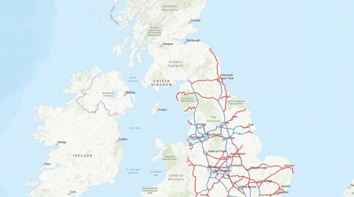
The latest iteration of Digital Roads is the release of its Network Model – a comprehensive geospatial representation of England’s Strategic Road Network (SRN), built in partnership with mapping experts Ordnance Survey and made freely available under an open government licence.
The Network Model is a highly detailed geographical information system (GIS) for the 4,500-mile SRN, which includes all of England’s motorways and major A roads. It contains nearly 30 different data layers, including attribution data about road names, locations, lanes, widths, transport links and nodes, and height and weight vehicle restrictions.
“Historically, National Highways was known as an organization responsible for designing, building and operating the physical infrastructure of the nation’s strategic road network,” says Coleman, who spoke in a presentation at the Highways UK event in Birmingham in October 2025. “Our bread and butter was not digital and data. It was building and maintaining roads and bridges. However, that’s changed.”
The organization has quantified this shift through a recent data-valuation study. “That study valued National Highways’ data at £69 billion, which is half the value of the roads themselves that our organization maintains,” says Coleman.
The Network Model alone accounts for over £5 billion of this value, with potential to reduce the estimated £3 billion in annual delays to the UK economy caused by pre-planned roadworks and events by giving transportation stakeholders and the public free access to an unprecedented level of geospatial detail.
It provides geographic consistency across five recently released APIs containing datasets such as road and lane closures and diversion routes. This common foundation enables what Coleman describes as a business-to-business-to-customer model, where National Highways delivers data through third-party platforms rather than solely through its own customer-facing channels.
“By making the Network Model data publicly available, we empower our partners such as wayfinders, local authorities, and researchers to enhance services, improve efficiency, and innovate,” says Davin Crowley- Sweet, National Highways’ director of digital technical competence.
The National Highways-Ordnance Survey partnership unlocks value across multiple dimensions. For safety, Coleman emphasizes that “geospatial data will be at the forefront in ensuring that customers are able to make more effective and earlier decisions, helping customers plan better routes, avoid disruption and reach their destination safely.”
For customers, access to quality interoperable data means a smoother, more reliable experience, reducing duplication and increasing accuracy. For the wider transport ecosystem, the common geographic foundation enables all participants to work from the same baseline.
“By combining National Highways’ change intelligence with geographic operational insight, the ecosystem can detect and respond to change faster, promoting a proactive, data-driven approach,” says Coleman. “We want our customers to be better informed and have trust in the journey information they access to ensure they’re safe and can reach their destination safely.”
GIS for traffic management
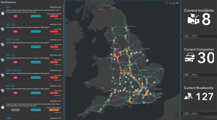
The Network Model forms part of a broader digital ecosystem that also includes Single View of the Network (SVN). Beginning its rollout in 2022, this internal real-time operational GIS platform has transformed how National Highways monitors and manages the SRN in real time.
SVN enables operators to zoom in on specific locations, access CCTV feeds, and layer on different information, to show everything from congestion to active incident responses, with traffic officers visible on screen as they travel to emergencies. Benefits include being able to predict problem locations and deploy traffic officers more quickly, better coordination of roadworks to reduce disruption and optimizing traffic flows to reduce congestion and emissions. It also removes the need to maintain multiple road models within multiple systems.
“We’ve got a lot of different use cases in different road control rooms,” says Matt Burns senior project manager and product owner at National Highways. “We can see incidents a lot more quickly and react to them. Our vehicles update every 30 seconds, so we can see exactly whether they’re in the right place or not. We use it to ensure our staff are in the right place at the right time, so we can maintain our government-mandated KPIs.”
The overall refresh rate for traffic situations is even more impressive, with SVN updating every six seconds, pulling in data from traditional infrastructure sensors such as MIDAS (Motorway Incident Detection and Automatic Signalling) loops and CCTV feeds, while also incorporating modern crowdsourced platforms including Google and Waze. “If you’ve got a high trust score on Waze and you report a pothole you’ve just hit, it’ll also show on the Single View, so our traffic officers can see that,” says Alex Yates of National Highways.
The platform also extends beyond immediate incident response to encompass broader asset management functions. By showing how long issues have been reported and tracking the status of various road features it helps National Highways maintain the SRN more proactively. Traffic officers can identify and address problems before they escalate into more serious incidents.
“We can see incidents a lot more quickly and react to them. Our vehicles update every 30 seconds, so we can see exactly whether they’re in the right place or not” Matt Burns, senior project manager and product owner, National Highways
The system’s deployment is now comprehensive. “We’ve got this in our seven main control rooms, but now we’ve also fitted it into every single outstation,” says Burns. “We’ve got 38 outstations across the business – at every one you walk into now you’ll see these screens.”
Accurate mapping
Both the SVN and the Network Model, depicted via Esri’s ArcGIS platform, have required addressing a critical challenge: fragmentation. “Over time, numerous network models had developed across different legacy systems within the organization,” says Coleman. “Although these models all derived from similar sources, they gradually drifted apart, maintained in isolation by different teams at different frequencies.”
Bringing those disparate sources together required what David Russell, a principal geospatial consultant at Ordnance Survey describes as “a key piece of data infrastructure”: its National Geographic Database, containing 500-600 million geographic features with 20,000 changes processed daily.
“Data management and quality assurance are absolutely critical to every activity that Ordnance Survey does,” says Russell, who also spoke at Highways UK in Birmingham. “That’s why National Highways partnered with us. We’re used to managing and developing this kind of critical data. We provide data to numerous organizations, and we are very much a future-focused, data-driven organization underpinning billions of pounds worth of projects in the national economy.”
The decision to release the Network Model publicly has exponentially increased its usefulness. “Through collaboration and the granting of an exemption from Ordnance Survey, the Network Model does not just provide our own organization with our Single View of the Network, but gives the ability to share this data via open government license for the whole public to use,” says Coleman.
“Our vision for the digital roads of the future will incorporate new capabilities, such as digital twins, predictive planning, single view of assets, and connected autonomous vehicles,” says Crowley-Sweet. “Each of these initiatives will require a common, trusted representation of the network to be successful.”
“A great man once said, ‘You can’t use an old map to explore a new world.’ I don’t think this has ever been more true than it is today,” concludes Russell.
1. The Network Model is available now via National Highways Open Data at opendata.nationalhighways.co.uk. For further information, contact Digital Lab Geospatial at spatialportal@nationalhighways.co.uk.
Why location matters
Thomas Coleman, National Highways’ head of geospatial, explains the fundamental importance of geospatial data through several observations:
“Location matters. Every event that happens on the strategic road network happens somewhere, and every asset that supports it exists somewhere.”
“The human brain processes images 60,000 times faster than it does text, and 93% of communication is nonverbal. That’s why geospatial is such a powerful tool in decision making. It lets us see data, not just read it.”
“How do we connect pavement data with lighting data when there’s no common key? We do it by creating a shared geography – a common spatial foundation across systems and platforms,” he explains. “That’s exactly what our network model was created for.”
But geospatial capabilities offer more than just integration. “Geospatial doesn’t just help us find a single version of the truth – it can also uncover a single version of the untruth, and that’s a good thing. If we can see where data doesn’t align, we can identify quality issues and continuously improve. If I showed you this same dataset without a geospatial view, you wouldn’t notice that something was wrong.”
Why Ordnance Survey?
Ordnance Survey supports more than 65,000 members in public sector organizations and over 10,000 developers. “This is underpinning government policy and activity,” says Russell. “Services that many take for granted are underpinned by Ordnance Survey data and geography.”
The organization is also expanding beyond its traditional GIS and geography user base. “We’re working with data environments like Snowflake and Databricks to ensure that we’re getting data into data analysts’ and data scientists’ environments, rather than just our traditional GIS geographer organizations,” says Russell.
He cites accuracy, authority, innovation and international reach as core strengths, pointing to AI-powered feature extraction from aerial and satellite imagery and work on next-generation transport solutions using positional accuracy and APIs.
“We’re creating future digital infrastructure that will underpin government policy but also reach out to the general public and commercial organizations.”
“We’re really making the most of our reach into different parts of government,” Russell notes, while the team extends this internationally. “We’re talking to international organizations about how to leverage data from geospatial infrastructure, which is now seen as being critical.”
Advertising & editorial opportunities
Want to be featured in the forthcoming 2027 edition? Explore advertising and editorial opportunities to put your organisation, expertise or solutions in front of the industry.
For more information, please contact Karen German.
Tel: +44 (0)1322 626961
Mobile: +44 (0)7939 286517
.png?h=400&iar=0&w=1400)
.png?h=628&iar=0&w=1200)
.png?h=400&iar=0&w=1400)
Get up to speed on the mobility industry - our newsletter straight to your inbox!