.png?h=400&iar=0&w=1400)
SMART DUBLIN: HOW DO YOU CHANGE A CITY’S BEHAVIOUR?
The City of Dublin has teamed up with VivaCity and Bentley Systems to create a real time digital twin that fuses sensor, traffic and environmental data, enabling data driven decisions for safer, greener travel across the city and its boroughs. Intertraffic spoke with Jack Kavanagh, Dublin City Council’s Open Data Lead, about what this means in terms of how a smart city reacts to certain situations and how active travel is central to much of the thinking.
Smart Dublin, an initiative of the four local authorities in the Dublin region to support innovation, has been trialling new technology to measure and monitor active travel and support Dublin City Council’s ambitious goal of ensuring that everyone in the city is within five minutes or 500 metres of an active travel route.
Achieving this means upgrading streets, junctions and public space to support walking, cycling and other modes, and using data to make the right decisions and evaluate the impact of schemes – in other words, assessing and editing how the city behaves and reacts.
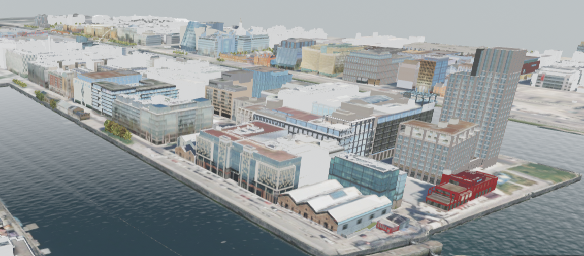
As part of this vision, Dublin is trialling a new digital twin, bringing together multiple data feeds in real time. Working together to create an end-to-end solution, the Smart Dublin follows the NVIDIA Blueprint for smart city AI, a workflow that enables city-scale AI from simulation to training to deploying with video analytics AI agents.
The proof-of-concept platform combines Bentley Systems’ 3D geospatial platform Cesium and NVIDIA Omniverse to enable real-time visualization and analysis of active travel sensor data. Dublin currently uses VivaCity’s AI traffic sensors, powered by NVIDIA Jetson and NVIDIA Metropolis platforms, to collect multimodal traffic data and behaviour insights on various types of road users, achieving very high levels of accuracy in identifying close passes for cyclists, drivers and pedestrians across Dublin’s roadways. All these streams are fused into a 3D model of Dublin that updates in real time, enabling transport planners to see what’s happening on the ground and to simulate future changes.
As Jack Kavanagh, Dublin City Council’s Open Data Lead, explains, the project is providing previously unachievable levels of data-fuelled insights into how the City is ‘behaving’.
SMART CITY, SMART THINKING
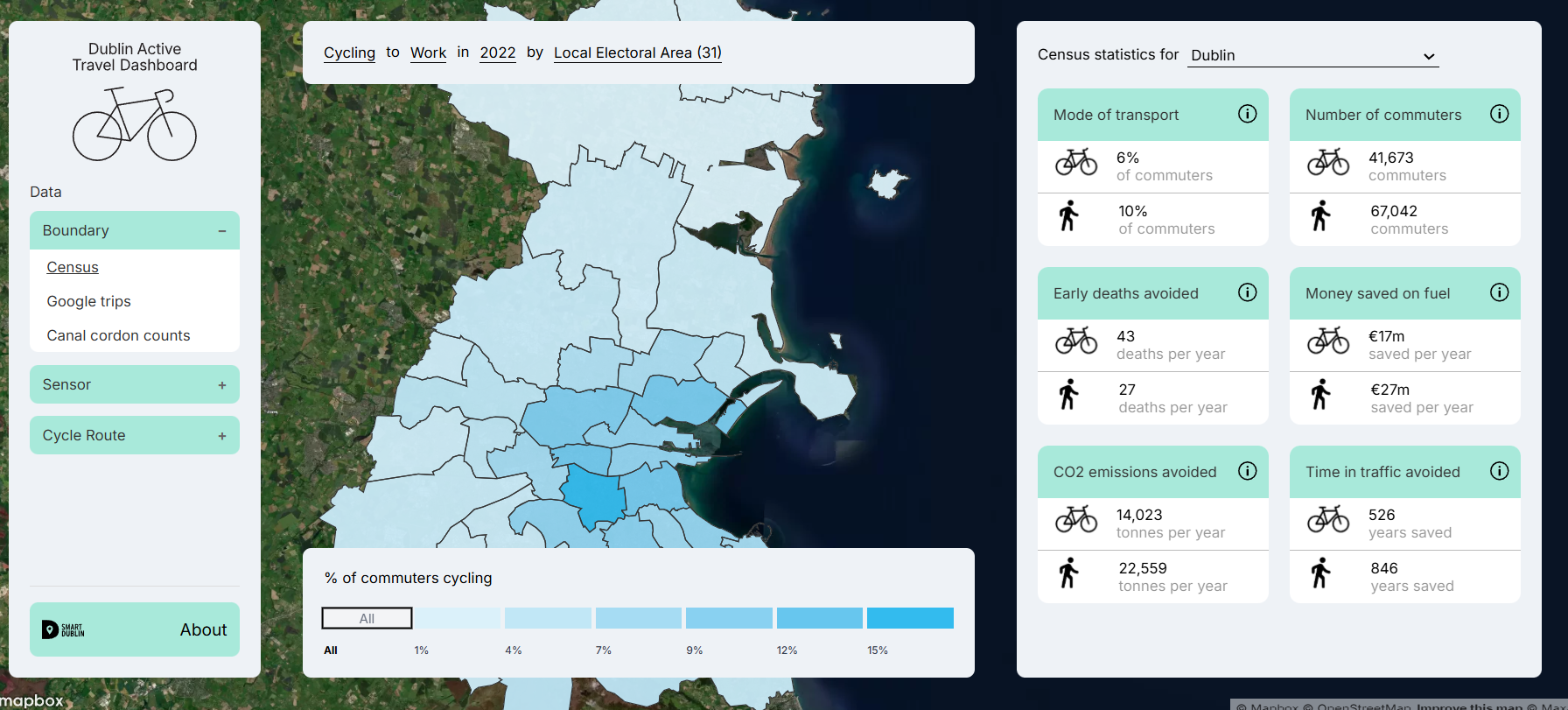
“What Smart Dublin does is bring together academia and businesses and technology to Look for new solutions to improve the quality of life of Dublin citizens. A lot of the projects that we're involved in are things like AI camera sensors, but we are also involved in the creation of the New York Dublin portal,” he explains, referencing the interactive public art installation that connected the two cities with a live video stream. “My particular role is the Open Data lead and I coordinate open data across the four Dublin local authorities. We also built an active travel dashboard, which brings together all of the existing open data on active travel.”
Smart Dublin was set up in 2016, says Kavanagh, with individual parts of the city being the subject of their own, dedicated projects.
"Smart Dublin was set up in 2016 with five individual districts of the city now having the subject of their own dedicated smart projects"
“There's five smart districts in Dublin. We have Smart Docklands, which focuses on the docklands area, and they specifically look at a lot of things to do with community outreach and engagement. We have Smart D8 in that postcode that focuses on health and wellbeing. And then there's also Smart DCU Focuses on creating an inclusive environment, including being the world's first autism-friendly university campus, and uses digital twin technology. Then we have Smart Balbriggan that involves significant community engagement through public surveys to identify and tackle the area's most pressing challenges and Smart Sandyford that addresses challenges like mobility and connectivity in the business district, using satellite data to map accessibility and providing e-bikes.”
HOW SMART DOES A CITY NEED TO BE?
It's fair to say that some cities’ claims to be “smart” and not entirely founded on truth or reality and the “smart” part is doing no more than paying lip-service to a current technological trend. It’s patently obvious that Smart Dublin is a genuinely intelligent city – so how does Dublin react if you poke it?
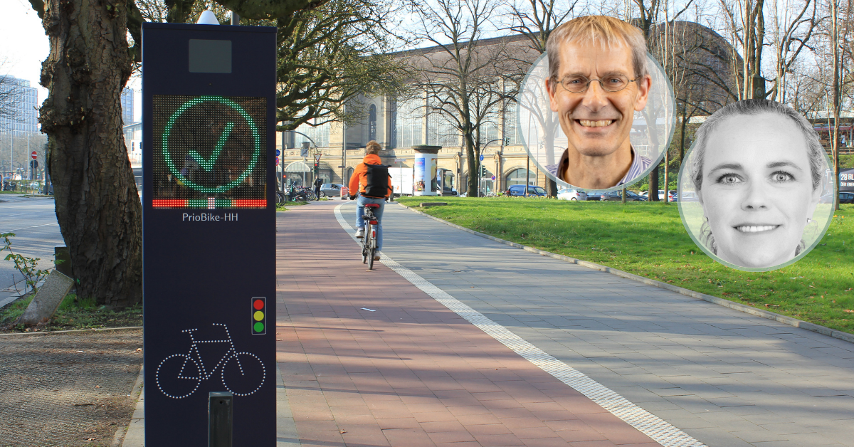
“The installation of the VivaCity AI camera sensors is really interesting,” Kavanagh replies. “These AI camera sensors measure things like modal splits, so the percentage of people cycling, walking or driving or on public transport. They also measure things like speed times. They can measure what we call close pass or near miss collisions, and it's particularly interesting that we're using them to monitor two new active travel routes, the Kilmainham to Thomas Street route and the Clontarf to city centre route, which is the city's flagship new active travel route, built to very high standards.
"'These AI camera sensors measure things like modal splits, so the percentage of people cycling, walking or driving or on public transport"
“It's great to have these technologies. There some other technologies that we've trialled recently include Lane Patrol, which is a cycle safety assessment tool. It’s an app that takes lots of little photos, and then from those photos it uses AI technology to rate the relative safety of the cycling network.”
THE MEASURE OF SMARTNESS
Does Kavanagh think that to be a truly smart city, the smarter it gets, the quicker it reacts and responds and adapts to the users’ needs?
“I think it does, yes,” he answers instinctively. “But I also think a lot of this technology is still in its infancy. I think getting the data quality right is still really difficult, and integrating data that is measured and comes live from cities into the working processes is difficult. However, that's something that we're striving to do in Dublin, and we're striving to have more data-driven decision-making, so things aren't just random, and we're actually basing the decisions we make on data and facts.
''I think a lot of this technology is still in its infancy. Getting the data quality right is still really difficult, and integrating data that is measured and comes live from cities into the working processes is difficult"
To change a city's behaviour then, requires not only the technology to do it, but it also requires a forward-thinking city to want it and need it and know how to use it. Changing one person’s behaviour is very difficult – so how do you go about not only changing the behaviour of almost 1.5 million people, but the behaviour of the city itself? Nudge theory, is the summary of Kavanagh’s reply.
“Changing behaviour is always difficult. As an example, the active travel teams in the various Dublin councils do a lot of work to try and nudge behaviour. There's been quite a few interesting projects over the last few years that involve nudging behaviour, primarily to get people to use active travel and this can include things like bike libraries. So they've trialled some bike libraries where bikes are given out to people for free to try and get to the point where people become regular cyclists. We're trying to figure out how long you've to give someone a bike for before they decide to invest in one themselves and become a regular cyclist.”
TWIN APPROACH
Dublin City Council is also involved in a number of digital twin projects, with two major pilot actions in particular that are in play as part of T4R (Twin for Resilience) local digital twins, an EU-funded programme, along with France, Germany and the Benelux countries. Local Digital Twins (LDTs) are virtual representations of territories, such as cities, created using advanced technology that models and simulates real-world data. These 'twins' can be used as powerful tools for innovation, allowing for the visualisation, analysis, simulation and prediction of territories in ways previously unimaginable.
“There's two digital twins we're building at the moment,” explains Kavanagh. “One is just of the Docklands, and we're building it in collaboration with an Irish gaming company, Real Sim. And the focus of that twin is for planning use cases, so planning and development, where we're integrating all the future planned buildings into the digital twin, so people can have an idea of what Dublin will look like in 5-10 years’ time.
“We've also integrated for some interesting data from other river level monitor sensors that we've installed along the River Liffey. So that's one digital twin we have, and then the other digital twin is Dublin's active travel dashboard, which is a 2D digital twin. Not all digital twins have to be 3D,” he says, interrupting himself. “This one focuses on dashboard data from all things related to active travel. So we've data coming in from Google Environmental Insights Explorer, Strava Metro, from VivaCity, AI cameras and also more static data from the Irish census, which we have linked to some qualitative metrics on health, wellbeing and the environment, just to make the data a little bit more interesting.”
"We're integrating all the future planned buildings into the digital twin, so people can have an idea of what Dublin will look like in 5-10 years’ time"
DISABLED PARKING AND THE ADVENT OF DRONES
Finally, Intertraffic was intrigued to hear more about Smart Dublin’s foray into the world of drones and also by the city’s innovative disabled parking sensors. Kavanagh is only too happy to fill in the gaps.
“Dublin City Council has a drones unit that is looking for different use cases to utilize drone technology to improve services in the city, particularly on things like mapping and LiDAR. This is where it's been quite successful, and filming and getting content for the city, but they're investigating other use cases on how to bring drones into the city, and we're looking into a lot of things to do with drone delivery,” he explains.
“It’s a very controversial topic at the moment, particularly in Dublin, as not everyone likes drones, but personally I find it super interesting, and it's great that as well, that an Irish company, Manna, is at the forefront of the industry, and I know in certain parts of Fingal County Council, you can actually get via drone. It's not the case in other parts of the city yet, but it looks like it will be rolled out fairly soon. But again, there's quite a lot of opposition to that, and rightly so, as drones can be quite disruptive and noisy. It's about balancing the benefits of the new technology with the risks associated from the externalities of things like drones.”
As for the aforementioned disabled parking sensors, it’s equally interesting but a lot less controversial a topic to discuss.
“We have in-ground disabled parking sensors in two Dublin local authorities. The sensors let us know whether a parking space is in use. There is an app that people can log on to to see which parking sensors are free. And there's some interesting data we've got from this that we figured out that the busiest disabled parking space sensor is the one outside a McDonald's, which probably means it's not entirely always being used by people with a disability! I think it's really good to have because it gives people with disabilities peace of mind that they know they won't have to circle around for a long period of time looking for a space.”
Share your story
Do you have an innovation, research results or an other interesting topic you would like to share with the professionals in the infrastructure, traffic management, safety, smart mobility and parking industry? The Intertraffic website and social media channels are a great platform to showcase your stories!
Please contact our Sr Brand Marketing Manager Carola Jansen-Young.
Are you an Intertraffic exhibitor?
Make sure you add your latest press releases to your Company Profile in the Exhibitor Portal for free exposure.

Get up to speed on the mobility industry - our newsletter straight to your inbox!